

|
|
Overview Since 1967, INCOG has been collecting and using geographic information to support the decision and policy making of elected officials and community planners. Using geographic information systems (GIS), INCOG maintains a strong regional and local mapping program. INCOG continues to provide a variety of mapping and data resources to support our agency programs and member governments. GIS is a proven tool in spatial analysis and support of how local governments operate.
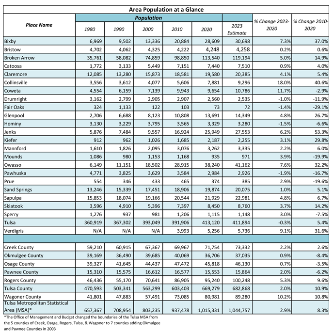
As computer technology has advanced, INCOG has migrated our spatial data and aerial imagery into an Environmental Systems Research Institute (ESRI) ArcSDE Enterprise geodatabase. This has given us the capability to migrate many of our mapping products to online web maps that remain up to date and available to the public to at no charge. For more information, contact: Aerial Photography Our coverage area is approximately 942 square miles and encompasses all the City of Tulsa and Tulsa County, as well as the City of Sapulpa in Creek County, the cities of Sand Springs and Skiatook in Osage County, the cities of Catoosa, Collinsville, Claremore, Owasso and Verdigris in Rogers County, and the city of Broken Arrow in Wagoner County. INCOG members within the coverage area receive a set of aerial photographs either in digital format, for those with GIS, or large size paper plots for those communities not using GIS currently. Aerial photographs are made available to the public for a fee. See maps and pricing list for more details. Demographics The table below shows the area communities population change over time. Other links to data sources for demographics can be found in the maps and data resources links.
Map and Data Resource Links
Customer Map Request To make a map request please fill out the Customer Map Request Form and submit it to INCOGmaps@incog.org Please allow 3 to 5 days for your map request to be completed. If we have questions, one of our staff will contact you to confirm the details of your map request. |
|
|||||||||||||||
![]()